Chapman Creek Trail – Oct 21, 2012

Today was an exciting day.  In between visiting numerous studios & galleries during the Sunshine Coast Art Crawl, I took some time to attend the official opening of the Chapman Creek Trail. This new trail is a very important connection in what will be the Suncoaster Trail connecting Langdale to Earl’s Cove…80km by highway and much longer by trail.  What is important about this trail is the new bridge that crosses Chapman Creek…the only non-highway crossing of the main watershed here on the Sechelt Peninsula.
The trail was actually christened in July during BC Bike Race.  Volunteers raced to have the bridge installed just days before 500 riders hit the Coast for the prestigious race.  Today was a beautiful fall day to dedicate the trail and to honour the many, many volunteer hours that went into building the trail.

The forest is watching

This section of trail runs from the Sechelt Airport near Wilson Creek to Selma Park.  Today I only hiked the first section which is about 20 minutes from the airport to the bridge.  It is a beautiful, fairly easy hike…just some uneven ground and a bit of a hill at the very end as you return to the airport.  From the airport, it is a short distance to the B&K Road network of trails which is a prime mountain bike area.

downstream from the bridge
the highlight – the bridge itself

We’ve had a bit of rain the last two weeks, so everything was a deep rich green.  Lots of ferns, moss, and thick vegetation.  Pine needles rained down and covered the trail.  There are some very large old stumps from the original grand forest that I am guessing was logged 70-100 years ago.

upstream from the bridge

Chapman Creek is also home to the Chapman Creek Hatchery which is a bit downstream from the bridge.  Here, millions of salmon are released each year and are now returning to spawn.  Here is a short video clip to try and share the power of the water.

Langdale Trail – June 23, 2012

I can’t believe a nearly a month has gone by since I have had a good hike in the forest.  We’ve had lots of rain and I’ve let work and meetings take too much priority.  I had a sunny afternoon to myself and made the most of it.  I decided to go exploring in my own backyard.
Langdale Trail – easy & level hike
Our street ends a block from the house and is the beginning of a trail through the forest.  This is the first trail I ever explored on the Sunshine Coast.  My neighbour, Jo, took the ladies of our cul-de-sac on a guided tour to share an easy trail we could all hike.  Jo passed away last fall, and I was thinking of her today and thankful that she shared this trail with me and starting my hiking trips.

The trees here are fairly young…new growth I’m sure after logging.  These are skinny, fast growing trees…maybe alder.  Almost all deciduous…the mighty Douglas fir and yellow cedar are further up the mountain.  Looking straight up at the sky the leaves rustled in the slight breeze.  The walk was very peaceful with birds singing and enjoying the sunshine.

Salmon berries are ready to eat

 The trail is lined with what I believe are salmon berries.  They are orange and turn red when ripe.  A delicious snack along the way.

Ten days from now this trail will be the end of stage 5 of the BC Bike Race.  500 riders from around the world will fly down the trail descending from much higher on Mt. Elphinstone as they race to the finish line at the ferry terminal below.  I look forward to cheering them on.

Oak Street Trail – May 25, 2012

Today was absolutely beautiful with full sunshine.  Summer weather has arrived.  After dinner, we decided to take a stroll along the beach and watch the sunset.  Bonniebrook Beach is just outside of Gibsons and is a wonderful place for watching sunsets over Vancouver Island in the distance.  Ocean Beach Esplanade is 2-3km long and only local traffic, so there are more walkers and bikers than cars most of the time.  We had just started walking when I noticed a new trail sign, so we took a detour and look what we found.
Oak Street Trail – look at the size of that stump!
 What an entrance!  Imagine how tall that tree was to leave a stump that big.  I had no idea there was a hiking trail here…I’ve always just walked along the beach.  It isn’t even on the SCRD’s trail maps yet.  We decided to explore and see where it led.  What a great trail for an evening hike!  The whole trail couldn’t have taken more than 10-15 minutes and connects to the end of a neighborhood road.  If you follow the trail up the road, you end up in Whispering Firs Park along the Sunshine Coast Highway.
Birds and frogs were singing and large ferns covered the forest floor.  Rushing water from a creek could be heard in the distance.  There were other trees as large as the entrance stump that had fallen and were creating a hotbed of regrowth.  The first part of the trail is a bit steep.  You are hiking up the bank from the ocean, afterall.  Not terribly difficult, but not accessible to everyone.
Educational display & map of the area
 As you come back down the path, there are glimpses of the ocean in the distance.  You can hear the pounding waves more than you can see them from the forest.  As we came out to the clearing, we imagined what is was like for pioneers and explorers to cut through think forest only to find the Pacific Ocean before them.  Absolutely incredible.  We finished the evening with a stroll along the beach to watch the sunset.  So simple, yet so special.
Bonniebrook Beach


Hidden Groves – May 12, 2012

Today felt like summer had arrived.  Everyone was so happy to see sunshine and warm temperatures that it was a must to spend as much time outside as possible.  So after stocking up at the Sechelt Farmers’ & Artisans’ Market, I headed for Sechelt’s Hidden Groves along Sechelt Inlet.  It was the grand opening & ribbon cutting for the new fully accessible trail.  “Take It Easy” or “ayat-tsut” (in shíshálh ) is about 500m of level meandering trail through the forest open to anyone.  Wheelchairs, scooters and strollers joined the group today for the opening hike.
Take It Easy / ayat-tsut

This is another one of our fabulous Sunshine Coast trail systems that is only possible because of extremely dedicated volunteers.  This single trail was built over the past few months and required over 600 hours of volunteer sweat & hard work.  Many local companies and the District of Sechelt came together with materials and equipment, and a number of important grants were earned from various foundations to create a financial base.

The area has a large network of trails that include a number of old growth giants estimated to be 750 years old.  This was my first trip to the area, but the sights from this short trek were fantastic.  Look at this old beauty standing, but at an amazing angle.

new shelter at the trail entrance

I look forward to my next hiking trip to Hidden Groves when I have time to explore all of the trails….and many more days of warm sunshine like today.  If you’re not tempted enough…have a look at the Hidden Groves brochure.

Mt Elphinstone Snow – March 23, 2012

Today we really turned the corner into spring. Sunshine and warmer temperatures were enough to get just about anyone outside. Daylight hours are extending with every passing day giving us even more opportunities. Not only was the fabulous weather calling me outside, but this was catch up time with my good friend and motivator Char. Our schedules haven’t allowed us to spend much time together lately, so I was excited to have time 1 on 1 to chat.

Of course, hiking with a fitness coach and personal trainer means you are going to get a good workout. We attempted to hike Torrent up to The Ridge which is both aggressive cardio and a fabulous reward of unique terrain at the top. Unfortunately, I missed a turn somewhere so we just kept going up the yellow trail. This trail eventually reaches the summit, but that means 4 hours in each direction. Too much time for an average Friday for these two busy women.

This was our turnaround point. I figured that if we had hiked high enough to find snow on a 10 degree (that’s 50F) day, we had done our climbing for the day. I’m not in fitness trainer shape, but just knowing that I was able to have a consistent conversation during a fairly aggressive climb means I have improved a lot over a couple of years. I know I will sleep well tonight and hopefully dream of the grand cedars & firs that accompanied our journey.
Here is to more Friday afternoons with good friends.

Langdale Falls – March 16, 2012

You know what it’s like when you have a week filled with meetings, presentations and stress? I hadn’t been able to hike all week, part bad weather and part too full a schedule. Friday was a day reserved for rejuvenating and getting out in nature. I looked forward with excitement to meeting the ladies for a hike.

It seems we all needed a bit of sunshine and fresh air, so we took a longer route and headed for Langdale Falls…up and over the falls and around to the powerlines before circling back up “Nuts” to our starting point. All together a great workout and just over 1.5 hours. “Nuts” is a short little trail segment, but it is a quad burner that is all uphill at the end of the hike. It’s a very pretty area, and that makes it a little easier. It’s a good measure of progress…a trail that you do a little faster each time…a little less winded each time.
There were many tree limbs down from the recent windstorm, but the forest is incredibly green. This spot is near Langdale Creek and is just full of moss. So many shades of green between the moss, ferns, and trees. Hello Middle Earth?

We have received a lot of rain the past couple of weeks so the creeks are all running full. There were stretches along Langdale Creek where we were stepping along rocks because the creek was higher than normal. It’s loud & powerful and pure. Just wait until the snow starts melting. There is a lot of fresh snow on Mt Elphinstone right now.
Just after this point in the hike is the most challenging. You need gloves as you back your way down a steep set of rocks only then to have to hike back up a steep section. Kudos to the team that attached ropes to this section. Having something else to hold on to while you climb this steep part is just the security blanket one needs to safely conquer this section of trail.


Langdale Falls up close.
Let’s hope there aren’t so many days before the next trip to the forest.

Soames Hill – February 4, 2012

It is days like these when I realize that I live in one of the most beautiful places in the world. Mountains, ocean, rainforest, clean freshwater streams, and fresh air all around….on BC’s Sunshine Coast. I woke up to streaming sunshine and decided that today was an exploring day.
I chose one of my favourite hikes: Soames Hill. I can see the summit of Soames from my kitchen window and love to head up on days to truly enjoy the view. For a change, I chose to challenge myself and head in from Soames Road on Marine Drive. What this means is starting at sea level (or close to it) and heading up for the full 250 meter climb.

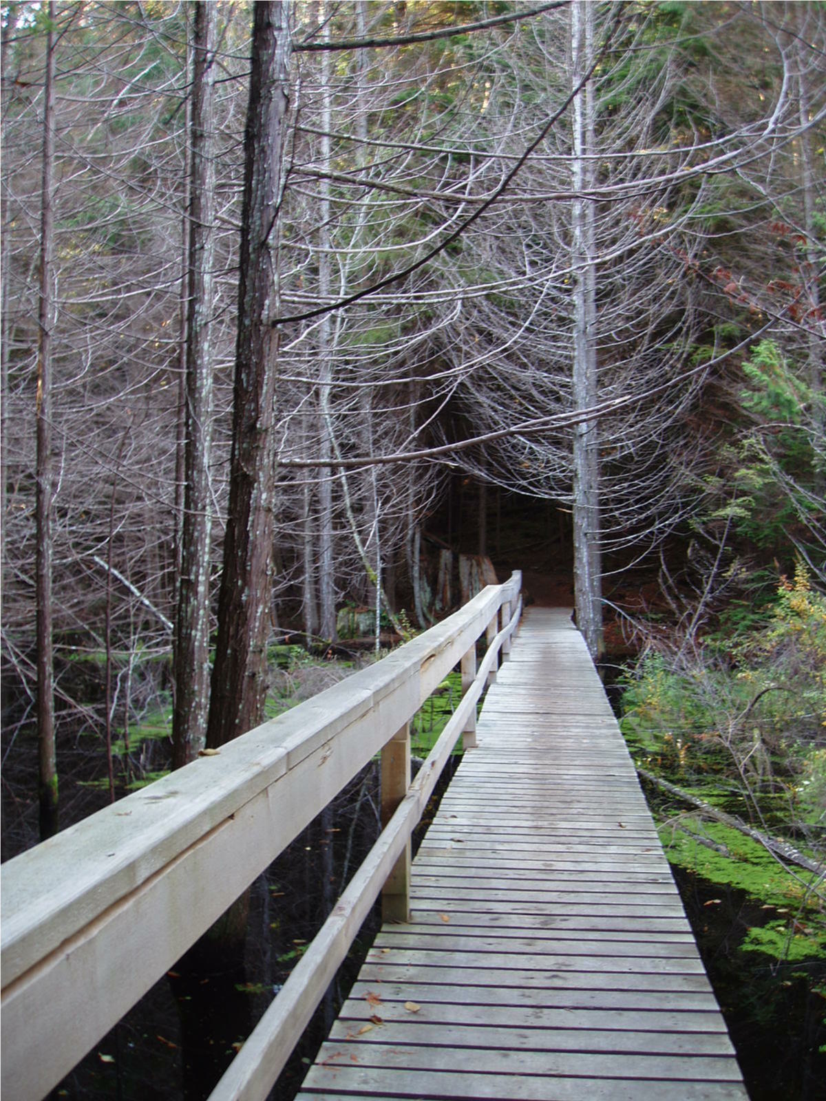
Of course this means stopping to catch your breath every once in a while. So I stopped to take a shot of this new bridge, courtesy of SCRD Parks staff. Thank You for the improved safety railings! The smell of freshly cut cedar just adds to the trip.

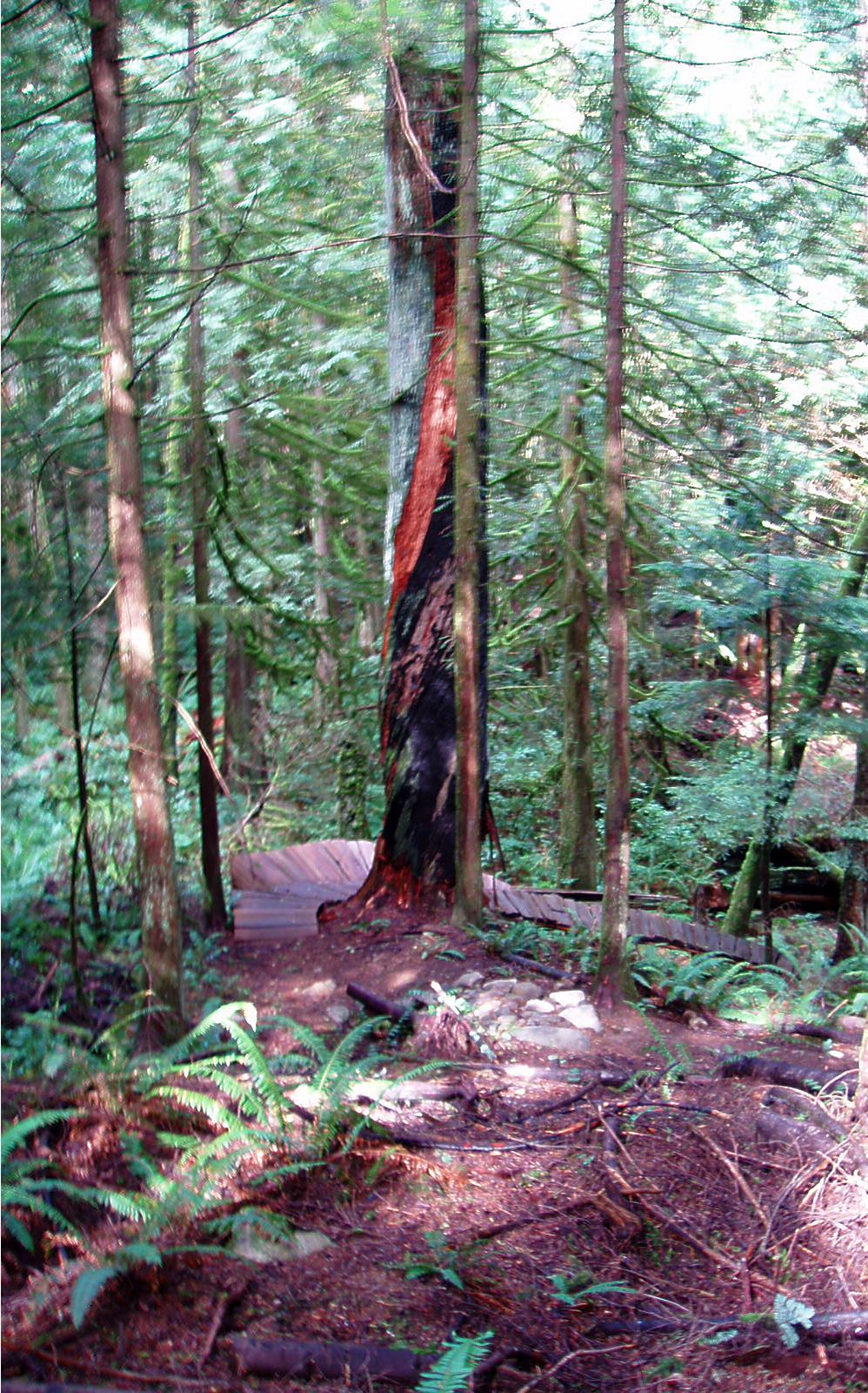
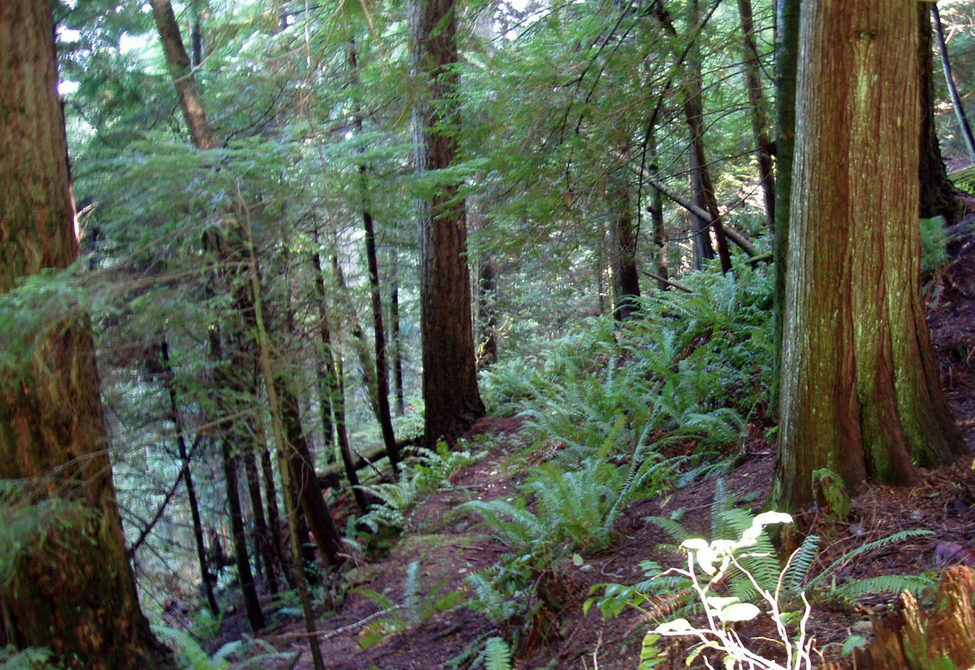
The lower part of Soames Hill is a winding network of moderate trails through beautiful 2nd growth forest. Many Douglas Firs take 2-3 people to reach around the circumference of a tree.

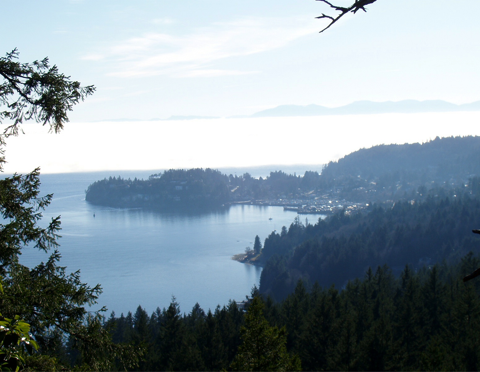
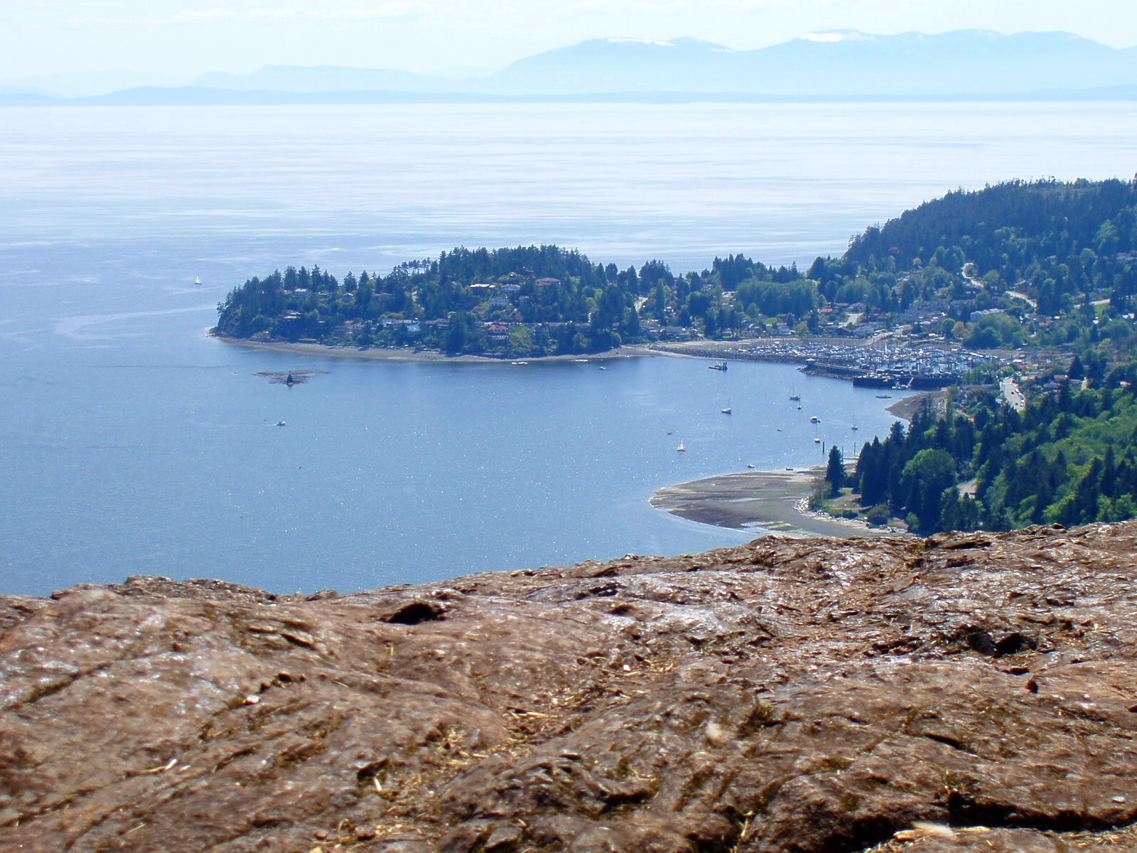
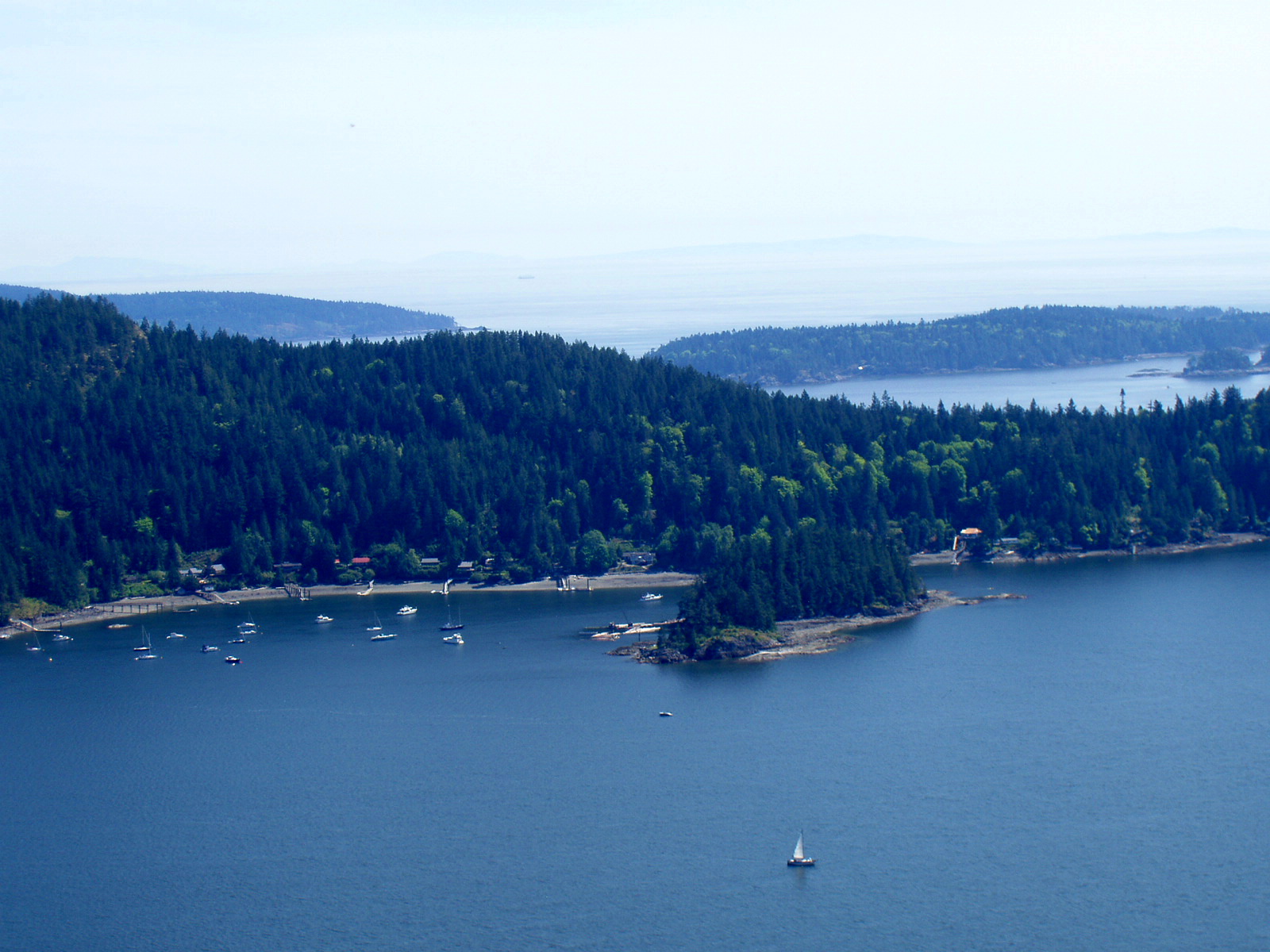
The top of Soames Hill is what sets it apart from other hiking trails. The views are simply amazing. Today was something special. Like I mentioned, there was full sunshine at my house today. This is not the case for anyone living directly on the Georgia Strait.
Look at the white strip in the middle of the photo. This is a massive cloud bank hovering over the Georgia Strait. You can just see the mountain tops of Vancouver Island sticking up in the background. Gibsons Landing is in the front of the shot.
It was a bizarre seen to sit and watch from above. The photo doesn’t do it justice. Picture a river of lava…bubbling, flowing to the sea. Turn it white, and this is what the fog made me think of seeing it from above. It was a big soft blanket…yet moving in the wind and churning. Big cotton balls of clouds with an uneven surface like a snowbank. I could hear a foghorn in the distance, probably the Nanaimo ferry or another ship hidden in the fog.
I felt blessed to take in this natural wonder and to enjoy a day of sunshine at this end of the Sunshine Coast.

Smuggler Cove – Oct 16, 2011


Today was a beautiful day….lots of sunshine, no wind, and temps in the teens (50’s F). One of those few days where I am almost happy not to have guests….so I can get out and experience the best the Sunshine Coast has to offer myself. Today I chose a new hiking adventure…Smuggler Cove Provincial Park.

Smuggler Cove is located in Halfmoon Bay…about 45 minutes from Arcturus Retreat B&B. It is a marine park with anchorage for boats and a 4km trail system from the land access point. Signs inside the park explain that it gets its name first from being a point to smuggle Chinese labor into Canada at the time of the transcontinental railroad, and second from American prohibition. Alcohol was smuggled from nearby Texada Island and eventually across the border to the US.

The first part of the trail is super easy hiking. I wasn’t paying close enough attention to note if it was completely wheelchair accessible…but it is definitely baby stroller ready. Long boardwalks like this take visitors past marshy areas. This area is not home to massive trees, but instead many many young deciduous trees. I hadn’t noticed how many leaves have already fallen until I saw this stretch of empty trees. The season is definitely changing as overnight lows are now into the single digits…upper 40’s F.
About 1/2 of the way down the trail, this even ground ends and the trail becomes narrower and rocky. It is still relatively easy hiking with small elevation changes, but there are stairs and lots of rocks. Hiking books and/or walking poles come in handy protecting ankles and assisting with balance.


The trail loop at the end is completely worth the reward. One easy climb up a bluff and “Hello Pacific Ocean”. Imagine being the passengers on this lone boat at anchor in the cove. Nothing but stars and a full moon tonight to enjoy. Summer is a more popular time for boats, but crowds are still unlikely.


This is my favourite spot. I must have sat out on the huge boulder for 30 minutes with no other human in sight. A sailboat off in the distance and the sound of gently lapping waves and a few birds…nothing to spoil the moment. An excellent inspiration spot…perfect for reading, painting, writing, or just dreaming. I’ll definitely be back to enjoy this view. The southern tip of Texada Island is off in the distance and Thormanby Island is closer just out of camera sight to my left.


Arbutus trees line the shoreline. The tree best suited for craggly rocky outcrops. It is the coolest tree that calls the BC coastline and areas of the Mediterranean home. It doesn’t loose its leaves, but instead sheds its bark each summer. This leaves the trees smooth and a unique orange hue.

I am going to have to find time for more hikes in Smuggler Cove.

Mt. Elphinstone – September 27, 2011

Fall has arrived on the Sunshine Coast. Yesterday we had our first major storm which left me and my neighbours without electricity for many hours while hydro crews collected tree branches from the power lines. Today the sun returned, so I decided to celebrate the afternoon with a hike on Mt. Elphinstone

Is this the coolest looking tree or what? Spiral bark pattern with remnants of the forest fire 80+ years ago. Take a look at the boardwalk at the base of the tree. I’ve really started paying attention to the actual trails. Who builds wooden platforms like this in the middle of the forest? Nature loving, hard working volunteers who have great passion for mountain biking, that’s who. Great work and kudos for sharing it with us hikers.

I was very impressed with the forest today. We’ve had over 2″ of rain the past couple of days, so I was a bit worried the trails would be muddy. Not a bit! There were small branches and pine needles scattered everywhere from the high winds but the trails were in fine shape. The forest floor soaks in moisture like you wouldn’t believe.


Recent rains mean the forest is exceptionally green this time of year. Moss is growing on fallen logs, ferns are sprucing up, and everything has new life with slightly cooler temperatures and plenty of moisture. I need to have someone teach me about the edible mushrooms.

This picture doesn’t really do it justice. You have to get out there and see for yourself. Sunshine was streaming in through the towering branches, birds were singing, and I was the only human in sight. It’s magical to take an hour in the middle of the afternoon to be quiet, get a good cardio workout, and be immersed in the natural environment…less than 5 minutes from my front door.

Soames Hill


Spring has truly arrived…just in time for Victoria Day weekend. Three weeks since my last real hike and I can feel it…mentally and physically. Why do I let time slip by without getting outside? I couldn’t pass up the sunny and warm afternoon, so I headed for one of my favourite spots: Soames Hill.

A big THANK YOU to the SCRD parks staff for the installation of the new trail signs. Made of wood, they look completely natural along the trail and are a great resource for hikers. There is no getting lost in this park.

Since today was a bright sunny day, I headed directly for the green trail…the 250m summit. Since I haven’t been hiking regularly of late, I was feeling the cardio workout. My quads gave a cheery “Hello!” at about step 150..(there are 206 stairs). But this hike is completely worth the effort. The view from the top is simply amazing.


I could sit up there for hours. It is a great place to think, to relax, and soak in the sun. The rockface at the summit shows the power of the mountains and the ocean is such a deep blue. It was low tide today…you can see the sandy beach ringing the land. This is Gibsons Harbour…a few more boats popping up as summer approaches. Vancouver Island is in the distance with a few snowcapped mountains still in view. My photo skills don’t do it justice. It’s an amazing 240 degree view.


This is the view to the southeast. Keats Island is in front with the Paisley Islands in the back. We can’t see these from town…only up this high can we see over Keats. Look at all the boats who have already arrived in Plumper’s Cove for the holiday weekend. It was just a little hazy. On a crystal clear day, you can see to Richmond and YVR.Paradise….just 5 minutes from home. One of the best places in the world to simply escape for a while.